

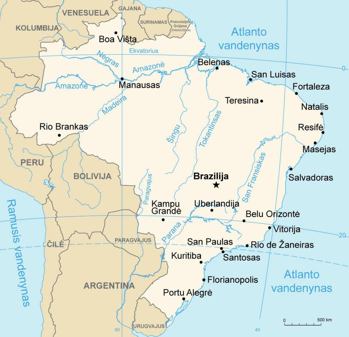
You can find on this page the Brazil geographical map to print and to download in PDF. The Brazil geographic map presents the topography, elevation, rivers, mountains, climate and physical features of Brazil in Americas.
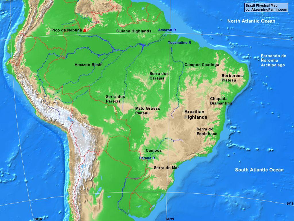
The Brazil physical map shows landform and geography of Brazil. This geographical map of Brazil will allow you to discover physical features of Brazil in Americas. The Brazil physical map is downloadable in PDF, printable and free.
Brazil physical features can be grouped into five main physiographic divisions as you can see in Brazil physical map : the Guiana Highlands in the North, the Amazon lowlands, the Pantanal in the Central-West, the Brazilian Highlands (including the extensive coastal ranges), and the coastal lowlands.
Brazil is a huge country that is made up of many different land forms. Some of Brazil major physical features are rain forests rivers, and waterfalls. Three of the most famous examples of these features are the Amazon Rain forest, the Amazon River, and Iguaçu Falls as you can see in Brazil physical map. The Amazon is a rain forest in South America.
Brazil has basically two major physical land features: plains and plateaus as its shown in Brazil physical map. It also has the world largest rain forest and a vast water basin with an extensive river system. The country is divided into five economic regions: North, Northeast, Southeast, South, and Central- West.
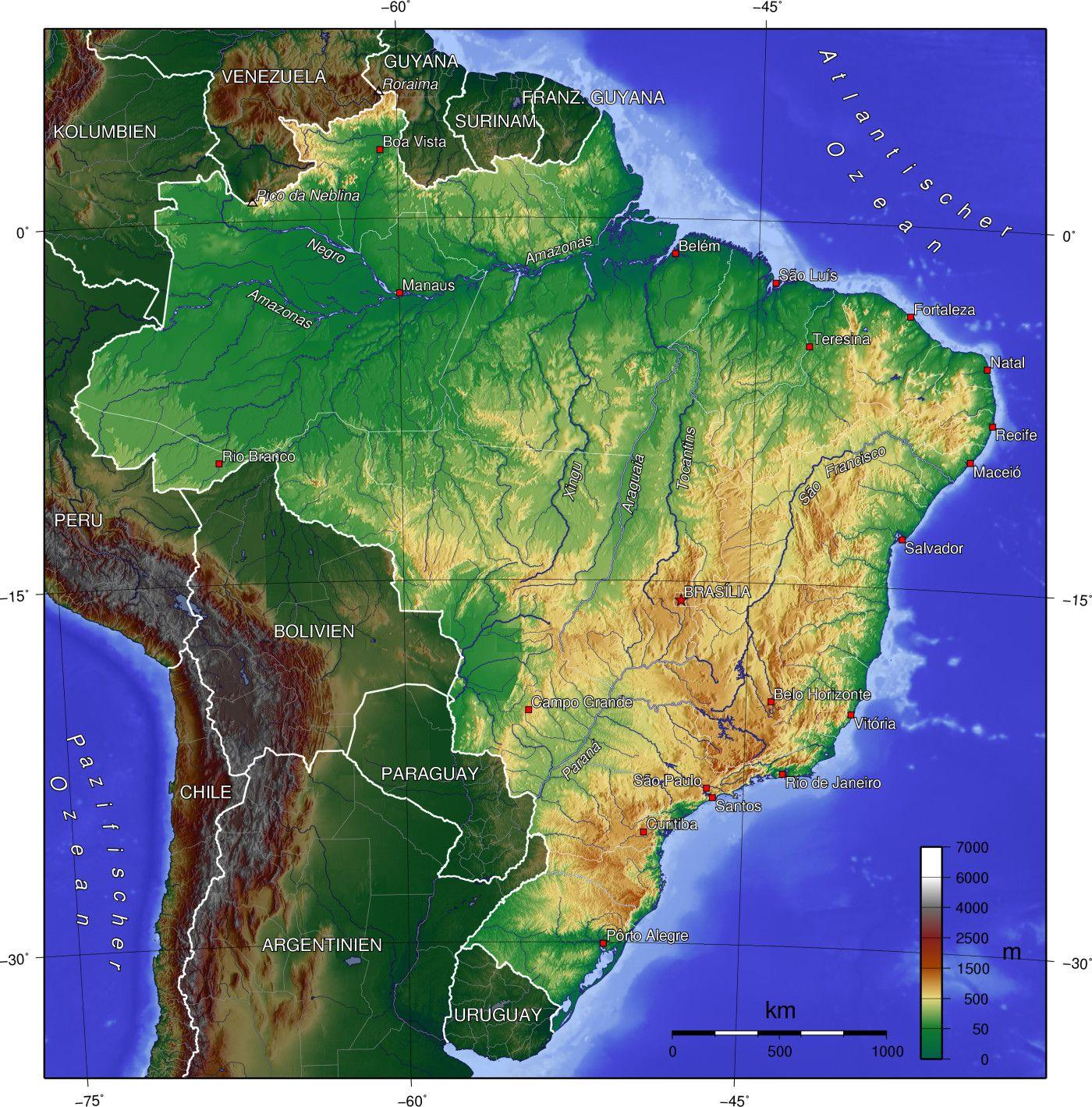
Brazil topographic map shows the physical features of Brazil. This topographical map of Brazil will allow you to discover landforms and geographical of Brazil in Americas. The Brazil topographic map is downloadable in PDF, printable and free.
The terrain of Brazil is mostly flat to rolling lowlands in north; some plains, hills, mountains, and a narrow coastal belt. Approximately 60% of the Amazon rainforest is contained in Brazil, what comes to 3.300. 000 square kilometer as you can see in Brazil topographic map. This rainforest is located in the Northwest of Brazil. Brazilian topography is also diverse and includes plains, highlands, and scrublands.
The northern topographic part of Brazil is dominated by the basin of the Amazon River and its many tributaries, which occupies two-fifths of the country. The Amazon Basin itself occupies 7,049,975 sq km (2,722,000 sq mi), or about 40% of South America total area as its shown in Brazil topographic map. The Amazon River (Rio Amazonas) is, at 6,436 km (4,000 mi), the world second-longest river after the Nile, although the Amazon ranks first in volume of water carried; rising in the Peruvian Andes, the Amazon eventually empties into the Atlantic Ocean at an average rate of about 198,000 cu m (7 million cu ft) per second.
Brazil is located in east-central South America and occupies 50% of the continent. Around 58% of the country is covered by forest and has the largest rain forest in the world, the Amazon Rainforest. Although Brazil is immense in size and varies in topography from the sweeping sea-level Amazon basin in the north to the mountainous areas of São Paulo and Porto Alegre in the south, the temperature range is slight a its mentioned in Brazil topographic map.
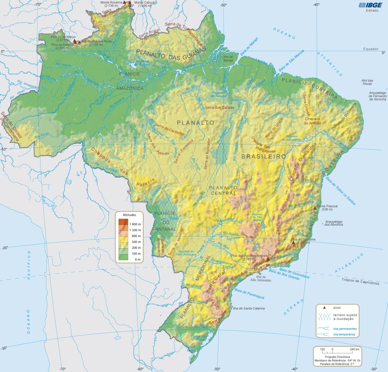
The Brazil elevation map shows the different altitudes of Brazil. This altitude map of Brazil will allow you to know where are the highest and lowest regions of Brazil in Americas. The Brazil elevation map is downloadable in PDF, printable and free.
Much of the Brazilian terrain lies between 200 metres (660 ft) and 800 metres (2,600 ft) in elevation as its shown in Brazil elevation map. The main upland area occupies most of the southern half of the country. The northwestern parts of the plateau consist of broad, rolling terrain broken by low, rounded hills.
The southeastern section is more rugged, with a complex mass of ridges and mountain ranges reaching elevations of up to 1,200 metres (3,900 ft). These ranges include the Mantiqueira and Espinhaço mountains and the Serra do Mar. In the north, the Guiana Highlands form a major drainage divide, separating rivers that flow south into the Amazon Basin from rivers that empty into the Orinoco River system, in Venezuela, to the north. The highest elevation point in Brazil is the Pico da Neblina at 2,994 metres (9,823 ft), and the lowest is the Atlantic Ocean as you can see in Brazil elevation map.
Pico da Neblina (Portuguese pronunciation: [ˈpiku dɐ neˈblĩnɐ], Fog Peak) is the highest mountain in Brazil, 2,994 metres (9,823 elevation ft) above sea level, in the Serra do Imeri, a section of the Guiana Highlands on the Brazil–Venezuela border as its shown in Brazil elevation map. As determined by a border survey expedition in 1962, its summit lies just within Brazilian territory, at a horizontal distance of only 687 m (2,254 ft) from the Venezuelan border at Pico 31 de Março.

The rivers in Brazil map shows the principal rivers with their names of Brazil. The rivers map of Brazil will allow you to find the main rivers which flow in and through Brazil in Americas. The Brazil rivers map is downloadable in PDF, printable and free.
Brazil Most Famous River is The Amazon. No other river in Brazil can ever match the status of this river. Amazon is the second longest river in the world and the largest by volume of water discharged as its mentioned in Brazil rivers map. Amazon river supports most of the ecosystem and rich biodiversity within its basin and provides water to the population of the basin and beyond.
The second largest river in South America after the Amazon, Parana is another major important river that flows through Brazil. The huge basin of this river with its numerous tributaries supports life in the region. Not to be confused with San Francisco in the USA, the Sao Francisco River is the largest river that runs entirely within the territory of Brazil as you can see in Brazil rivers map. The Araguaia River is a major river of the Eastern Amazon region of Brazil. Together with the Tocantins, this river flows through some of the most biologically rich and important regions of Brazil.
The Tocantins River is also known as the central fluvial artery of Brazil because it flows almost through the middle of the country and is really important for the river transportation of the country. Paraguay River is another major South American River that flows through Brazil. The river originates south of Diamantino in the province of Mato Grosso in Brazil as its shown in Brazil rivers map and is a part of one of the major commercial shipping routes network between Brazil, Paraguay, and Argentina.
The mountains in Brazil map shows the principal mountains with their names in Brazil. The mountains map of Brazil will allow you to find the main mountains ranges and highest mountains of Brazil in Americas. The Brazil mountains map is downloadable in PDF, printable and free.
The South American country is more than lush rainforests and beautiful beaches as its mentioned in Brazil mountains map. Brazil boasts countless rolling mountains, volcanic hills, shell-mountains and massifs. Some can be climbed, others can not. One is an active volcano. Brazil is a sprightly 517 years old, but has some of the oldest geology on the planet, including the Tumucumaque, Imeri and Pacaraima mountain ranges.
The Mantiqueira Mountains (Portuguese: Serra da Mantiqueira) are a mountain range in Southeastern Brazil, with parts in the states of São Paulo, Minas Gerais and Rio de Janeiro as you can see in Brazil mountains map. It rises abruptly from the northwestern bank of the Paraíba do Sul River and extends northeastward for approximately 320 km (200 mi), reaching a height of 2,798 m (9,180 ft) at Pedra da Mina. The Espinhaço Mountains (Portuguese: Serra do Espinhaço) is a mountain range in eastern Brazil. The range runs roughly north and south through the states of Minas Gerais and Bahia, and forms the divide between the upper watershed of the São Francisco River and those of the shorter rivers which flow east into the Atlantic, including the Doce, the Jequitinhonha, and the Pardo. Pico do Itambé rises to 2033 meters.
Serra do Mar (Portuguese: Sea's ridge or Sea ridge, [ˈsɛʁɐ du ˈmaʁ]) is a 1,500 km long system of mountain ranges and escarpments in Southeastern Brazil, which runs in parallel to the Atlantic Ocean coast from the state of Espírito Santo to southern Santa Catarina as its shown in Brazil mountains map, although some include Serra Geral in the Serra do Mar, in which case this range extends to northeastern Rio Grande do Sul.

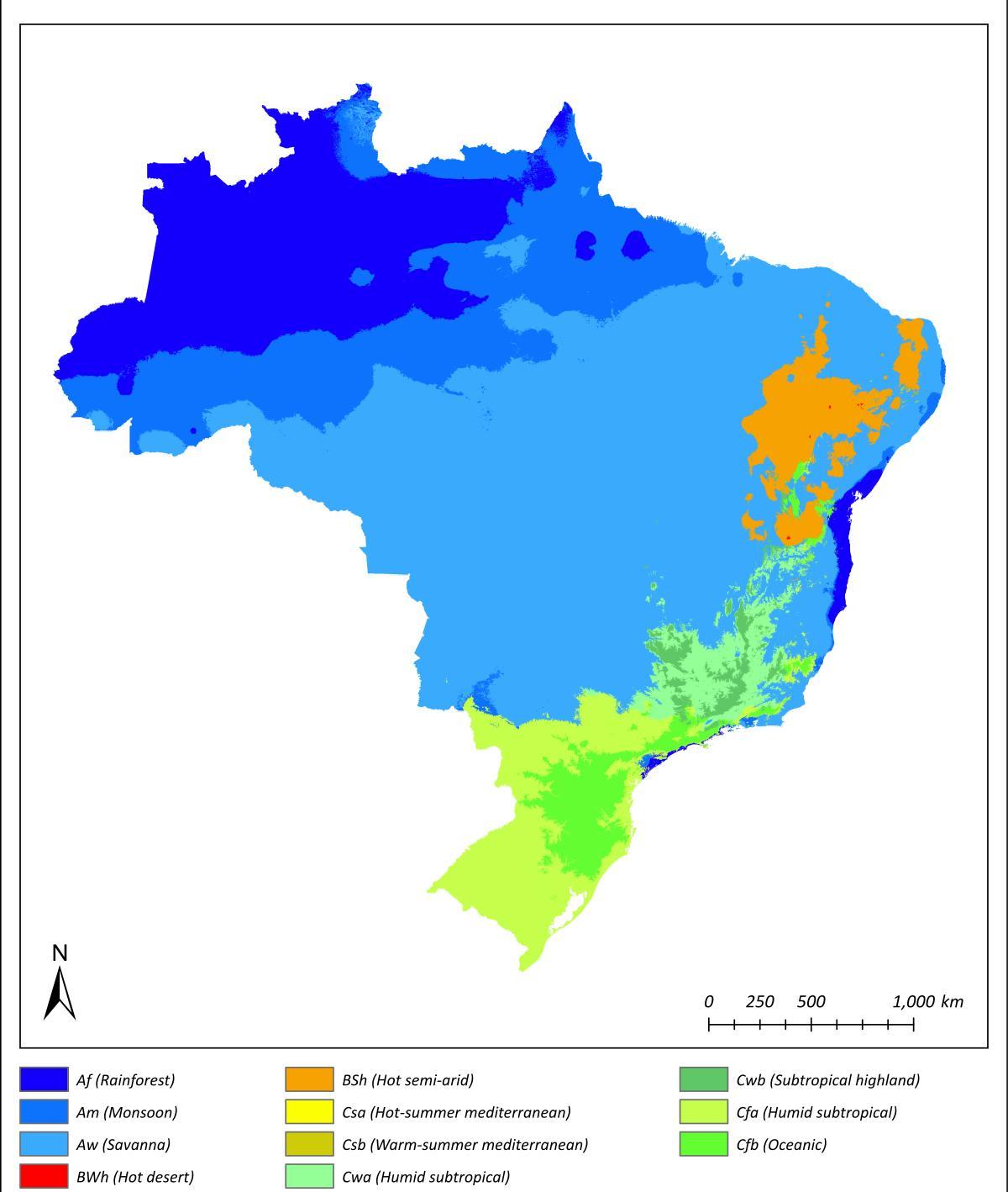
The Brazil climate map shows average temperature and climate zones of Brazil. This climate map of Brazil will allow you to know weather, average precipitation, average sunshine and different climates of Brazil in Americas. The Brazil climate map is downloadable in PDF, printable and free.
The Climate of Brazil varies considerably from the mostly tropical North (the equator traverses the mouth of the Amazon) to temperate zones below the Tropic of Capricorn (23°27' S latitude), which crosses the country at the latitude of the city of São Paulo. Brazil has seven climatic regions as its mentioned in Brazil climate map: equatorial, tropical, semiarid, highland tropical, temperate, subtropical, and oceanic. Temperatures along the equator are high, averaging above 25°C (77°F), but not reaching the summer extremes of up to 40°C (104°F) in the temperate zones. There is little seasonal variation near the equator, although at times it can get cool enough for wearing a jacket, especially in the rain.
Precipitation levels vary widely. Most of Brazil has moderate rainfall of between 1,000 and 1,500 mm a year, with most of the rain falling in the summer (between December and April) south of the Equator as you can see in Brazil climate map. The Amazon region climate is notoriously humid, with rainfall generally more than 2,000 mm per year and reaching as high as 3,000 mm in parts of the western Amazon and near Belém. It is less widely known that, despite high annual precipitation, the Amazon rain forest has a three- to five-month dry season, the timing of which varies according to location north or south of the equator.
High and relatively regular levels of precipitation in the Amazon contrast sharply with the dryness of the semiarid Northeast, where rainfall is scarce and there are severe droughts in cycles averaging seven years. The Northeast is the driest part of the country as its shown in Brazil climate map. The region also constitutes the hottest part of Brazil, where during the dry season between May and November, temperatures of more than 38°C (100.4°F) have been recorded. However, the sertão, a region of semidesert vegetation used primarily for low-density ranching, turns green when there is rain. Most of the Center-West has 1,500 to 2,000 mm of rain per year, with a pronounced dry season in the middle of the year, while the South and most of the East is without a distinct dry season.